
Short hike to Lago dell Fate, near Macugnaga, Italian Alps

Lago dell Fate, near Macugnaga, Anzasca Valley, Italian Alps
If you’re looking for spectacular scenery, look no further than Macugnaga in the Anzasca Valley, Italy. When we visited in mid-July, the highest mountaintops were still covered in snow and the sight of several glaciers tumbling down the mountainside was breathtaking.
Easy hike to Lago dell Fate
Firstly, we soon discovered after we arrived at Macugnaga that there aren’t many hikes that don't involve well over 1,000m height gain or carrying your dog on the chair lift (and given that we have a 38kg Labrador with strong views on safety, this was never going to be an option for us) You can take the gondola from Staffa up to Rifugio Oberto Maroli at 2786m and right on the Swiss border, but the walking options once you get up there seem very limited (unless you want to descend 1500m walking back down again).
So after pouring over maps for some time whilst drinking particularly delicious cappuccinos, we decided to walk to Lago delle Fate from Pecetto. This was in some ways a mistake – see the handy hints and tips below. Indeed we made multiple errors on our hike and reading this blog means you won't have to!
This easy walk near Macugnaga offers a truly alpine experience, with human activity (for once!) actually adding to the natural splendour, through ancient log cabins, geraniums etc.
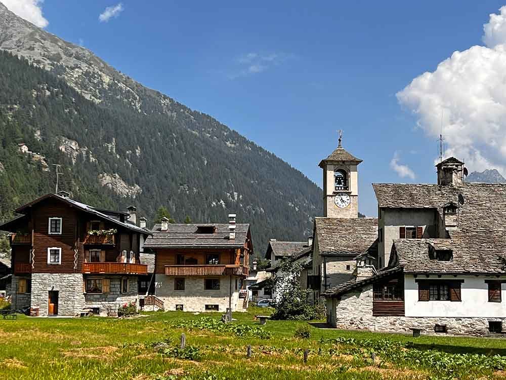
Old quarter of Staffa, Macugnaga
The walk down the Anzasca valley above the Torrente Anza from Pecetto to just beyond Ronco was quite frankly boring, especially given how stunning the area is. This was due to a poor combination (for us at least!) of a wide track/forest road, few views and Draco being unable to even put one foot/paw into the very ‘white water’ Torrente Anza. Near Isella, we headed along the enticingly named ‘Grande Traversata delle Alpi’ (which is part of the Tour of Monterosa) towards Lago delle Fate. Sadly, this track was also wide and not very interesting. So, our recommendation would be to do this walk by going and returning by the same way ie through Motta (see later).
Lago delle Fate (in fact it’s a tiny reservoir) is very beautiful, with a mountainous backdrop and milky turquoise waters. Unfortunately (given that it was over 30c) neither humans nor dogs can swim in it, and so we headed onwards with our panting dog. Thankfully both humans and dogs can paddle in the Quarazzola river/stream that feeds it – phew.
Onwards to Crocette
We decided at that point to walk on up the valley to the ‘dead village’ (la Citta morta) of Crocette. The village developed around mines that have existed since Celtic and Roman times, but intensive exploitation of ‘gold bearing quartz with pyrite’ didn't begin until 1927. The mine was abandoned in 1953 when demand for gold fell after the war. Unfortunately, the mining and especially processing activity left soil that is contaminated with arsenic, cyanide and mercury – all used to extract gold from the quartz. The area is safe – just don't pick mushrooms, avoid contact of the soil with skin or ‘ingest soil’ 🥴
The walk to and from Crocette was lovely, especially if you follow the narrow footpath close to the Quarazzola river, ie not the main drag. Mountains all around, beautiful woodland, a tumbling mountain river and negligible height gain: what more can you want? Probably uncontaminated soil, but let’s not dwell on that!
My Merlin app assured me there was a nightingale singing amongst the Crocette ruins, but I’m doubtful – it wasn't night, for one thing. Shame, because I’ve always wanted to hear one. But maybe it was a nightingale?

The ancient barns of Isella

The footpath to the old settlement of Motta
Return through Motta

The ancient mule track from Motta to Isella
On our way back down, we decided not to follow the main track but instead chose the narrow footpath through Motta. And we were SO glad we did!!
A stunning path down through the woods and meadows emerges above a small group of ancient houses and a large herd of goats - heralded by the tinkling of bells. A scene that can’t have changed for centuries – truly magical. And then you walk down an old mule track through mixed woodland – no idea how old the mule track is, but we're talking very many centuries, and it is also very beautiful.
The footpath through Motta is obvious on Mapps.Me and is very highly recommended indeed.
A (very!) brief history of Macugnaga
Macugnaga was founded in the 13th century by the Walser, a Germanic people who emigrated from the Vallese area.
The remnants of this early culture enrich all the villages through characteristic stone and wooden buildings built using the old ‘blockbaum’ technique. You can also see ancient bread ovens and barns and houses supported with pillars to prevent mice, rats and damp climbing up.
There are museums in Borca and Staffa where you can find out more.

Macugnaga, Anzasca Valley, Italian Alps
Tips/helpful info about Macugnaga
Narrow roads
The road up the Anzasca Valley (through the villages of Calasca Castiglione, Bannio Anzino, Vanzone con San Carlo, and Ceppo Morelli) is wider than most in the area but is still a definite squeeze at times and we think you’d struggle with a motorhome due to overhanging cliffs.
Good footwear
You need hiking boots anywhere in the high Alps – we'd even advise them on an easy walk such as this one (although if pushed we’d probably say walking sandals would do)
Start at Isella
Follow our advice above and don't do this walk from Pecetto. Instead, it would be much nicer to park at the extremely cute village of Isella and then enjoy a drink at Al Bar d’Isella after your walk – I gaily ordered an Aperol spritz and when it arrived complete with an unrequested selection of snacks/nibbles, was very worried about the price. I needn’t have been: 4 euros!
Where to eat
There are two bars/restaurants at Lago Delle Fante – both look lovely although Bar Ristorante Lanti is especially cute and better if you want lunch rather than a drink or snack. We chose Bar Ristorante Alpino overlooking the lake and shared a beautiful ice cream sundae – yum!
Where not to eat
Avoid La Locanda bar/ristorante at the bottom of the chairlift at Pecetto – stunning views, but a very mediocre lunch of one (small) course each and a beer set us back 48 euros. Ouch.
Details
If you love the mountains you’ll love Macugnaga
We visited in mid-summer and it was still reasonably quiet, so it will appeal to anyone who wants to escape the hoards that descend on say Chamonix in peak season. The village centres are lovely, and so we’d recommend going to Macugnaga even if you just want to have a coffee, a potter round the shops and museums, and a good lunch. The views remain exceptional.
A truly high alpine experience
Macugnaga offers a host of alpine/mountain activities such as via ferratas, canyoning, mountaineering, glacier crossing, rock climbing, mountain biking and horse riding. Human activity in the valley (for once!) actually adding to rather than detracting from the natural splendour, through ancient log cabins, geraniums etc. If you’re looking for spectacular scenery, look no further.
Himalayas of Europe
Magugnaga is often also referred to as the Himalayas of Europe, because the mountains have a real Himalayan scale. They rise from 1,249m in the village to the ‘four sister’ peaks of Monterosa: Gnifetti (4,554m), Zumstein (4,563), Nordend (4,609m) and the highest peak of Dufour (4,634). Punta duFour is the second highest peak in Europe and only slightly lower than Mont Blanc.
Macugnaga is a group of five hamlets
Nestled under the massive east wall of the Monte Rosa mountain chain, Macugnaga lies at the end of the Anzasca Valley which is sometimes called the ancient valley of the Antuanes, a tribe of Leponzi in the Iron Age.
Anzasca Valley, Piedmont, Italy
The Anzasca Valley extends from Piedimulera to Macugnaga – the final and largest village within Macugana being Staffa.